
Weather shapes nearly every aspect of human life, from agriculture and infrastructure to public health and economic activity. Yet most people have only a surface-level understanding of the large-scale patterns that drive the weather they experience. Knowing how these patterns work is not just intellectually interesting; it is practically valuable for planning, preparedness, and understanding the world around you. For more on this, see ASEAN Nations Strengthen Regional Cooperation Agreement.
Key Takeaways
- El Nino and La Nina: The Pacific Engine
- The Jet Stream and Why It Matters
- The Polar Vortex
- Tropical Cyclones: Hurricanes, Typhoons, and Cyclones
The global weather system is interconnected in ways that can seem counterintuitive. A warming of Pacific Ocean waters near the equator can cause droughts in Australia and floods in California. A weakening of the polar vortex over the Arctic can send bitter cold plunging into regions that rarely experience it. Understanding these connections helps you make sense of weather events that might otherwise seem random. For more on this, see 5 Habits That Separate Great Developers from Good Ones.
El Nino and La Nina: The Pacific Engine
The El Nino-Southern Oscillation (ENSO) is arguably the most important climate pattern on Earth, influencing weather across every continent. It describes a cycle of warming (El Nino) and cooling (La Nina) of sea surface temperatures in the central and eastern tropical Pacific Ocean.
El Nino
During an El Nino event, trade winds weaken and warm water spreads eastward across the Pacific. This shift in ocean heat redistributes atmospheric energy patterns globally. Typical effects include increased rainfall and flooding in the southern United States and western South America, drought in Southeast Asia and Australia, warmer winters in northern North America, and altered monsoon patterns in India and Africa.
Strong El Nino events can be devastating. The 1997 to 1998 El Nino caused an estimated 23,000 deaths and over 33 billion dollars in damage worldwide through floods, droughts, and associated disasters.
La Nina
La Nina is the cold phase, characterized by stronger-than-normal trade winds pushing warm water westward and allowing cool water to upwell in the eastern Pacific. La Nina typically brings the opposite effects of El Nino: drought in the southern United States, increased hurricane activity in the Atlantic, heavier monsoons in South Asia, and cooler, wetter conditions in Australia.
Critically, La Nina events tend to enhance Atlantic hurricane seasons. The reduction in vertical wind shear during La Nina creates more favorable conditions for hurricane development and intensification. Some of the most active and destructive Atlantic hurricane seasons have occurred during La Nina years.

The Jet Stream and Why It Matters
The jet stream is a fast-flowing river of air in the upper atmosphere, typically found between 30,000 and 40,000 feet altitude. It flows from west to east and acts as a boundary between cold polar air and warmer tropical air. The jet stream''s position and strength have enormous influence on surface weather patterns across the mid-latitudes, which is where most of the world''s population lives.
When the jet stream is strong and relatively straight, weather patterns tend to be stable and move steadily from west to east. When the jet stream weakens and develops large meanders, called Rossby waves, weather systems can stall, leading to prolonged heat waves, extended cold spells, persistent rain, or sustained drought. These blocking patterns are responsible for some of the most extreme and damaging weather events.
Arctic Amplification and the Weakening Jet Stream
The Arctic is warming two to four times faster than the global average, a phenomenon known as Arctic amplification. Because the jet stream is driven by the temperature difference between the poles and the tropics, this faster warming at the poles reduces the temperature gradient and tends to weaken the jet stream.
Research suggests that a weaker, wavier jet stream leads to more frequent and persistent extreme weather events. The record-breaking heat dome over the Pacific Northwest in 2021, which killed hundreds of people, was linked to a stalled high-pressure ridge associated with an amplified jet stream pattern. Understanding this connection is crucial for anticipating the types of extreme events that are becoming more common.
The Polar Vortex
The polar vortex is a large area of low pressure and cold air that circulates around the poles in the stratosphere, roughly 10 to 30 miles above the surface. Normally, the polar vortex stays confined near the North Pole, keeping frigid Arctic air bottled up at high latitudes.
But occasionally the polar vortex weakens or splits, a phenomenon called a sudden stratospheric warming event. When this happens, Arctic air can spill southward into the mid-latitudes, bringing extreme cold to regions unaccustomed to it. The February 2021 cold outbreak that devastated Texas, causing widespread power failures and hundreds of deaths, was associated with a disrupted polar vortex.
These events are becoming more closely monitored as scientists work to improve their predictability. While polar vortex disruptions are natural, research is exploring whether Arctic warming and sea ice loss may be making them more frequent or more severe.
Tropical Cyclones: Hurricanes, Typhoons, and Cyclones
Tropical cyclones are among the most destructive weather phenomena on Earth. Called hurricanes in the Atlantic and eastern Pacific, typhoons in the western Pacific, and cyclones in the Indian Ocean, these systems can generate winds exceeding 150 miles per hour, storm surges of 20 feet or more, and rainfall measured in feet rather than inches.
Trends to Watch
- Rapid intensification: Hurricanes are intensifying faster than they used to. Storms that strengthen by 35 miles per hour or more within 24 hours have become significantly more common. This makes forecasting more difficult and reduces warning times for affected populations.
- Slower movement: Research indicates that tropical cyclones are moving more slowly over land, which means affected areas experience damaging winds, rain, and surge for longer periods. Hurricane Harvey in 2017 stalled over Houston for days, dumping unprecedented rainfall.
- Poleward migration: The latitude at which tropical cyclones reach their maximum intensity has been shifting toward the poles, exposing new communities to hurricane-force winds and surge that their infrastructure was not designed to withstand.
- Wetter storms: Warmer air holds more moisture, and warmer oceans provide more fuel. The result is tropical cyclones that produce substantially more rainfall than comparable storms in previous decades.
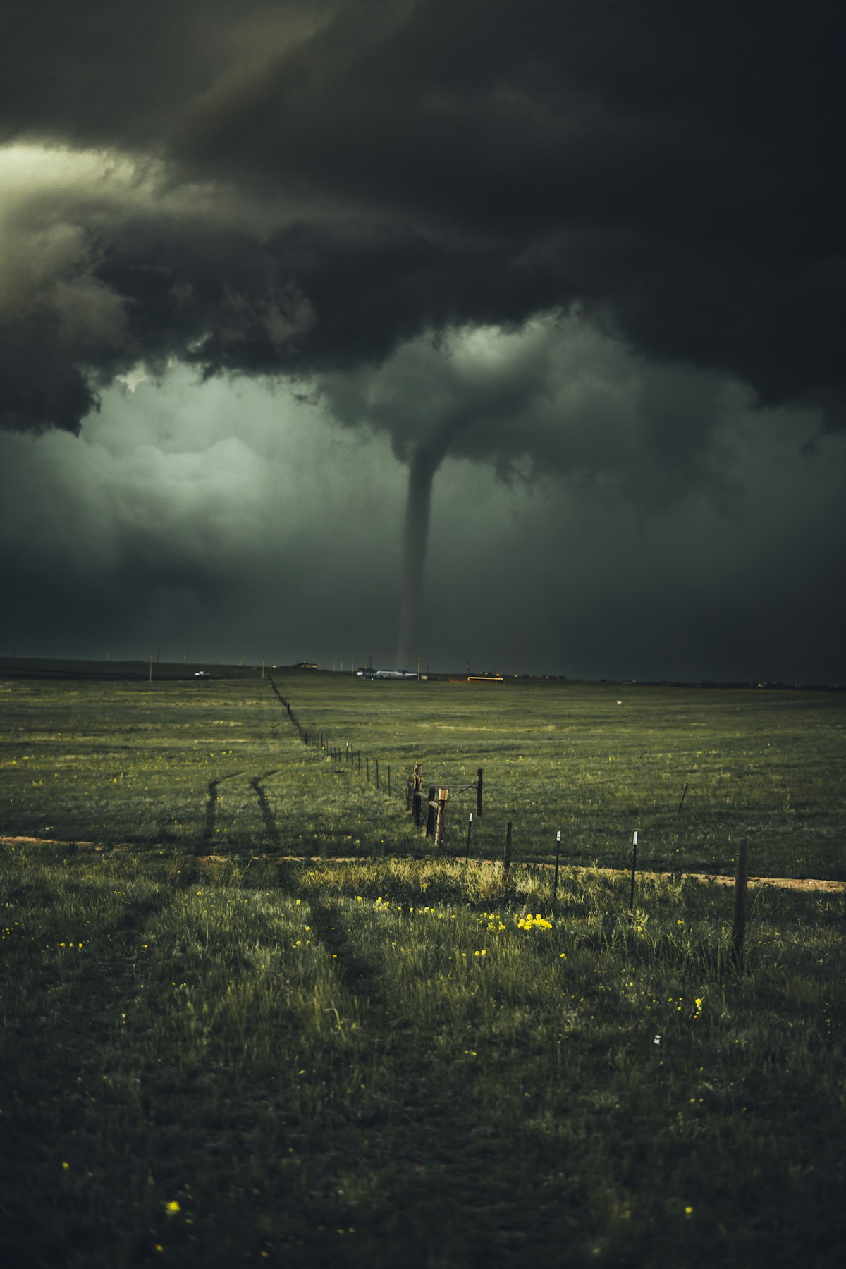
Severe Convective Storms: Tornadoes, Hail, and Derechos
Severe thunderstorms produce tornadoes, large hail, damaging winds, and flash flooding. The United States experiences more tornadoes than any other country, but severe convective storms occur on every continent except Antarctica.
Tornado Alley, traditionally centered on the southern Great Plains, appears to be shifting eastward into the Mississippi Valley and the Southeast. This is significant because the southeastern United States has higher population den For more on this, see 5G Changed Everything: The Real Impact Three Years Later.sity, more mobile homes, more tree cover that limits visibility, and a higher percentage of nighttime tornadoes, all factors that increase vulnerability.
Derechos, widespread wind storms associated with lines of severe thunderstorms, are another underappreciated risk. The August 2020 derecho that struck Iowa produced winds exceeding 140 miles per hour and caused over 11 billion dollars in damage, mostly to crops and infrastructure. These events can be as damaging as hurricanes but receive far less public attention and preparedness.
Atmospheric Rivers and Flooding
Atmospheric rivers are long, narrow corridors of water vapor transported from tropical regions toward the poles. When these moisture plumes make landfall against mountains, they can produce extreme precipitation. California, the Pacific Northwest, and western Europe are particularly vulnerable.
Atmospheric rivers are responsible for 30 to 50 percent of annual precipitation on the west coast of the United States and can deliver beneficial water supply. But the strongest atmospheric rivers cause catastrophic flooding and landslides. Research suggests that atmospheric rivers are becoming more intense due to warmer oceans providing more moisture, increasing the risk of extreme precipitation events. For more on this, see How Extreme Weather Is Changing Life Around the World.
How to Stay Prepared
Understanding weather patterns is the first step. Practical preparedness involves several layers:
- Know your local risks. Coastal areas face hurricane and surge risk. River valleys face flooding. The Great Plains face tornadoes and severe storms. Mountain regions face wildfire and flash floods. Understand what is most likely where you live.
- Have a plan. Know where you will go and what you will do for each type of hazard. Discuss your plan with family members. Identify safe rooms, evacuation routes, and meeting points.
- Maintain supplies. Keep at least 72 hours of water, non-perishable food, medications, flashlights, batteries, and a battery-powered weather radio.
- Stay informed. Follow your local National Weather Service office. Enable weather alerts on your phone. Pay attention to watches and warnings.
- Protect your property. Ensure adequate insurance coverage, maintain trees and drainage around your home, and address vulnerabilities before severe weather season.
The atmosphere is a dynamic, interconnected system, and the patterns that drive extreme weather are becoming better understood even as climate change introduces new uncertainties. Staying informed about these patterns is one of the most practical steps you can take to protect yourself and your community.
Related Articles on BlogVerdict
Summary Comparison
| Factor | Pros | Cons | Verdict |
|---|---|---|---|
| Cost | Various options | Premium can be expensive | Good value overall |
| Quality | High standard | Varies by provider | Research recommended |
| Accessibility | Widely available | Regional differences | Improving steadily |
| Support | Community + official | Response times vary | Adequate for most |
Related Reading on BlogVerdict
Explore more on this topic:
- How Extreme Weather Is Changing Life Around the World
- African Union Summit Focuses on Continental Free Trade Progress
- 5 Habits That Separate Great Developers from Good Ones
- 5G Changed Everything: The Real Impact Three Years Later
- ASEAN Nations Strengthen Regional Cooperation Agreement
Frequently Asked Questions
What is the main point from this article?
The most important insight is that understanding the fundamentals and staying informed about developments in this area can help you make better decisions and stay ahead of important changes.
Where can I learn more about this topic?
We recommend exploring the linked For more on this, see African Union Summit Focuses on Continental Free Trade Progress.resources throughout this article, following authoritative sources in this field, and checking BlogVerdict regularly for updated coverage and analysis.

